
Red River Bridges
Many bridges cross the Red River. The following bridges are Red River bridges that can be prone to river flooding. When the river is flooded, please refer to the FM Bikeways Map to find the nearest auto bridge. Most automotive bridges stay open during floods. Below is the current status of the flood-prone bridges:
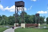
Lindenwood / Gooseberry Park Bridge (Exclusive to bikes / pedestrians)
Open
Open
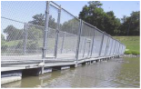
Midtown Floating Bridge (Exclusive to bikes / pedestrians)
Open
Open
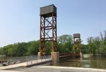
Oak Grove / Memorial Park Bridge (Exclusive to bikes / pedestrians)
Open
Open
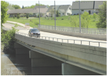
12th Ave N / 15th Ave N Bridge (Automotive bridge with bike path)
Open
Open
Construction Closures
During the summer there are often road construction projects that could affect Fargo-Moorhead's bikeways. For more information about road construction projects in Fargo, Moorhead, and West Fargo you can visit: www.fargostreets.com (Fargo); www.cityofmoorhead.com/departments/engineering/current-projects (Moorhead); www.westfargostreets.com (West Fargo)
Flooded Trails
The trails along the Red River can be prone to river-flooding. Below are the river elevations at which trail segments become flooded. To find the current river elevation, click on the link below.
Fargo
- 17 ft - Trail along Elm St between 14th Ave N & 15th Ave N
- 17.5 ft - Red River Trail near 13th Ave S (near water treatment plant)
- 17.5 ft - Red River Trail at Dike East / Midtown Dam
- 17.7 ft - Red River Trail under the 12th Ave N / 15th Ave N bridge.
- 18 ft - Red River Trail under NP Ave / Main Ave Bridges
- 19 ft - Approaches to Lindenwood / Gooseberry Park Bridge
- 20 ft - Approaches to Oak Grove Park Bridge
- 25 ft - Lindenwood Park Trail near river
- 17 ft - Red River Trail between Main Ave Bridge and 1st Ave N Bridge
- 17 ft - Red River Trail near Oak Grove Park Bridge
- 19 ft - Approaches to Lindenwood / Gooseberry Park Bridge
- 19 ft - Red River Trail at Davy/Memorial/Riverfront Park
- 20 ft - Approaches to Oak Grove Park Bridge
- 26 ft - South Rivershore Dr under I-94
- 27 ft - Trail in Gooseberry Park
After flood waters recede from trails, trails may be hazardous for biking for a period of time until cleared of mud and debris.